Articoli
DAKAR: AN AFRICAN TOWN

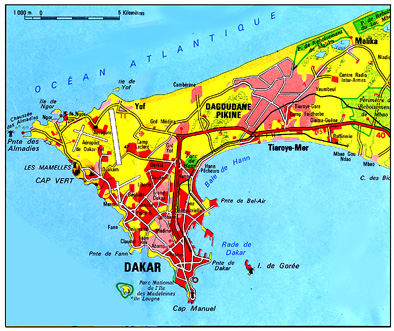
The peninsula of Cap Vert, a land area of 552 km2, extends into the Atlantic Ocean at the western extremity of Africa, with a three‑sided head formed of basaltic rocks and a long, relatively narrow sandy ‘neck’. The latitude and the particular conformation of the coast form a border at Cap Vert between the semi‑desert steppe of Sahel and the strip with the SudanGuinea climate, which is more fertile because the longer rainy seasons.
The slave trade to the West Indies had its origins bere during the period of trade between the 16th and 19th centuries. The white merchants settled in the islands to protect themselves from confrontations with the African people. The Portuguese occupied the Archipelago of Cape Verde offshore, while the French occupied Gorée Island, in front of the eventual site of Dakar, and St. Louis at the mouth of the River Senegal. Subsequently the French founded Rufisque, a port where peanuts were traded on the Southern Coast of the Cap Vert peninsula, setting the basis for the occupation of the whole of Senegal.
The wolof and lebu people, who lived on the islands and the mainland when the Europeans arrived, still occupied the rest of the peninsula which had been inhabited since prehistoric times. On the plateau, the tableland above sea level which was later the site of the colonial town, were the early lebu villages.
Towards the end of the 18th century the peninsula was inhabited by about 10 000 African people. In the following years some French people settled on the coast in front of Gorée Island. In 1846 a mission was founded near the indigenous village of Ndakar and in 1857 the French landed a contingent on the mainland. In 1862 the governor, Pinet‑Laprade, drew up the first town plan for the colonial town of Dakar, in which the area between the two points of Dakar and Bel Air became a port. Without any compensation the local population was forced to move away from the villages, which were needed for the expansion of the new trading centre. However, some buts remained on the plateau among the European houses.
At the beginning of the 20th century the port of Dakar was already competing with St Louis and Rufisque. In fact, the long railway connecting Bamako, 2000 km inland, with the shore of the ocean ended at the port of Dakar.
In 1904 Dakar had a population of more than 18 000 and was the scat of the government of French West Africa, replacing the Island of Gorée. In 1912 17 000 of Dakar’s 21 000 inhabitants were blacks. Even today there are African compounds in the centre of Dakar ‑ large or small yards with a low density occupation, where some communities live, practising small handicraft activities. In the 1940s, Dakar, then the administrative and industrial capital of French West Africa, drew a strong migration of workers from Senegal, Mauritania, Guinea, French Sudan (today’s Mali), Dahomey (today’s Benin), Togo, Ivory Coast and Gabon. The French community settled on the plateau and monopolized the politics and the macroeconomics, while the Syrian‑Lebanese people held commercial supremacy.
Today, although buildings in the commercial centre are rising higher, not all the signs of French colonial architecture have been destroyed. In the area near the port, the first centre of the city, some commercial buildings still have raw walls made of calcareous ‘Rufisque’ stone. Large trading houses, which managed the business of the region in colonial times, still exist.
The planned town after the second world war
After the second world war an indigenous ‘middle class’emerged, integrated in with the colonial administration. The Service Temporaire d’Aménagement du Grand Dakar (STAGD) was created in order to oversee the building of the ‘popular’ districts. At Rebeuss and Niaye‑Tioker some buildings emerged in swampy zones near the Plateau. However, the Medina, a piece of land with a particular status by which the occupation of its allotments was permanent, did not allow the ‘white town’ to displace the African areas.
The SICAP (Société immobilière du Cap‑Vert) was founded in 1951, with both public and private funding, to preside over the housing renewal. In 1952 it was decided to drive the inhabitants of some slums away towards an arca 13 km from Dakar called Dagoudane‑Pikine. This decision bad a great influence on the development of the town and today, about 40% of the population of the whole Cap Vert peninsula live in the area of Pikine. Between 1952 and 1960 the SICAP built 3,603 houses, while tens of thousands of people were driven away from the central areas, in order to eliminate the slums.
In 1956 Dakar, with more than 200 000 inhabitants, became the capital of Senegal, replacing St Louis. In 1957 the ‘Ecole des Hautes Etudes’ became a University. In 1957 and again in 1961 the townplanning scheme was modified. Between 1956 and 1958 ninety houses were built in the suburb of Derklé, with the help of the inhabitants, but without building contractors’ intervention, according to the French system of the Castors cooperatives. The houses cost about 280,000 F CFA, as opposed to 550,000 F CFA which would bave been necessary had building contractors intervened. Even today this remains the only example of organized auto‑construction in an urban environment in the whole of Senegal.
In November 1958, the Republic of Senegal was proclaimed within the French Community and in 1960 it became completely independent. In 1959 the OHLM (Office des habitations à loyer modéré) was founded. It cooperated with SICAP to improve the working‑class areas in the Northern part of the urban expansion between the ‘Allées du Centenaire’ and Colobane. In the 1960s the whole zone was characterized by slums, built on unhealthy lands near the industrial arca outside the two ‘official’ towns (Plateau and Medina). The area was subject to constant expansion without the provision of any urban services. The rebuilding plans foresaw self-construction, but in reality housing for the richer classes were more often built. Between 1965 and 1975, about 10,000 huts were pulled down and 130,000 inhabitants were driven towards the outermost suburb.’ In order to reclaim the land, drainage canals were built. The Allées du Centenaire ‑ today’s Bld Charles de Gaulle ‑ forming a 2 km long central axis pointing at the obelisk of Independence, and replacing the slums of Wakhinane, Daroukhane, Kip‑Coco, Almincou, Baye‑Gainde, and Ndondy 14. Unlike SICAP, which had created only small, low density villas OHLM provided different housing types, almost all based on European rationalistic building.
OHLM was financed by a 4% levy on wages (2% chargeable to the wage-earner and 2% to the employer). However, only a small part of the wage earners could live in these houses and in this way the wage‑earner or lower incomes contributed to financing housing for the more moneyed classes. At the end of 1964, for example, the cheapest houses were rented for 4600 F CFA per month. The saving‑investment dues requested for the assignment of a house in the SICAP or OHLM areas limited access to the emerging middle‑classes, made up, for the most part, of state functionaries. The lowest classes continued to live in the spreading slum areas, in the interstices of the town‑planned expansion, in the remaining lands without services, and even in the sinkings subject to floods.
New areas have been created which, according to the public authority, are ‘unlawful’, even if the inhabitants, following the customary law, had paid the lebu owners for the land. Even today, in the well established areas not yet recognized by the town‑planning scheme the lack of title‑deeds to property which has been properly registered is the principle cause of problems relating to ‘lawful’ tenure. During the 1960s and 1970s, the ‘unlawful’ areas increased, spreading from the centre of the city to the second urban division. In this way Xaar Yalla (from 1954 onwards), Grand Yoff, Arafat, Tivaouane, Thiaroye and Diamaguène emerged.
Pikine
The districts called Pikine emerged in 1952 around the workshop Icotaf, on a bare land without streets, electricity, clinics or schools. In the neighbourhood were some traditional villages: Cambérène, Thiaroye, Yeumbeul.
According to the town planning scheme of 1962, this area was bound to working class building. The development of Pikine can be schematized into a sequence of areas: Pikine ancien from 1952 to 1960, Pikine loti récent from 1960 to 1967, Pikine extension from 1967 to 1971 and Guédiawaye from 1971 onwards. Together with the enterprises ‘recognized’ by the public authorities, the lunlawful’ area of Pikine irrégulier developed during this period. The first allotments of ‘Pikine ancien’ were relatively large (200 m2). In order to sell them to other occupants, the first allottees halved them, leading to subsequent speculation. Some lands surrounding the first centre were immediately occupied by unlawful allotments.
Even today there is a ‘lawful Pikine’ and an ‘unlawful one’. The former was created by the public authorities, while the latter emerged spontaneously. The evacuees from the OHLM had legal occupation title decds. The others paid the lebu owners for their land but they settled outside the lawful allotments. The occupation titles assigned by the state, depending upon the value of the building allotments, were in reality a superficial right, rather than a document signifying ownership of the land.
In 1970 Pikine had a population of 123,000 and during the 1970s the unlawful or spontaneous areas spread eastwards as far as Yeumbeul. According to a 1976 population census, Pikine had 210,113 inhabitants, while the population of the Cap Vert region as a whole bad reached 940,920. Besides those who had been forced to move from Dakar city slums, there were also immigrants from the countryside and other cities, and citizens who decided to move, dreaming of being able to buy a house of their own. Therefore, Pikine, which started as a centre for people who used to live in the old slums, has become an urban centre with its own attractions.
The sociologist Fatou Sow has commented:
“Rebeuss, the Medina or Pikine represent a process of domination which cannot be regarded as emargination. It can be considered a peripherical subsystem, revealing the traditional rural/urban, traditional/modern, western/non-western dualism. It is according to this dualism that the relationships of a ruling production system on a ruled production system, in well defined fields, are organized in the space. Pikine, just as Abobo-Gare in the Ivory Coast, Surulere in Nigeria, or Poto‑Poto in Congo, organizes a ruled production system with its production activities of goods and services, its logic, its social structure, its specific solidarities. It doesn’t therefore belong to an ‘informal’ or emargination system, but it is actually indispensable to the functioning of the underdeveloped Senegalese economy dominated by French and international capitalism. It plays the role of taking in a part o the urban wage‑earners and a part of the lumpen‑proletariat.”
Meanwhile, in order to realize the new industrial zone and the HLM areas of the ‘Allées du Centenaire’, the inhabitants of the slums were driven away from Darou Khane (September 1971), Kip Coco (2500 families in May 1972), and also Angle Mousse, Baye Laye, Wakhinane, Nimzatt and Grand Médine. Sometimes a notice of déguerpissement was given to the inhabitants only 48 hours before the arrival of the bulldozer.
Ecochard’s town planning scheme
In 1967, when the city had 500,000 inhabitants, a town planning scheme devised by E. Ecochard was approved. The scheme was carried out in accordance with the prospect that Dakar would continue its steady growth of 6% per year and would reach 1,133,000 inhabitants in 1980. It limited the eastward expansion of Pikine along the ‘neck’ of the peninsula and foresaw the joining of Pikine and Dakar through the development of areas with an average population density of 200 inhabitants per hectare. In order to join the two big urban poles (Pikine and the SICAP-HLM areas), Ecochard proposed to cover more than 25 kM2 with small houses. He defined this idea as the atout capable of avoiding the decadence of the new suburbs.
The ‘parcelles assainies’ (supplied plots)
At the beginning of the 1970s the statistics showed that 80 percent of the population of Dakar had insufficient revenue, to be able to afford a house with urban features. SICAP and OHLM only granted accommodation to the 20% of the population who had fixed incomes and could pay the minimum rent. In 1972 the World Bank chose Senegal as the country where it would finance one of its new experiments for the habitat under welfare scheme, which consisted of the so called parcelles assainies, the provision of roads to the allotments, drinking water, sewerage system, an electricity grid and community facilities. The plots were assignéd to the families who had an income of US$ 40‑120 (1972 $). The World Bank lent $8 million, repayable over 50 years, to the Senegalese Government. This loan covered 79% of the total cost of the project, amounting to $10.1 million. Today, the increase in dollar value from 256 to 400 CFA Francs has considerably raised the value of interest rates and consequently the debts of the Senegalese economy which have increased by about 56%. At the beginning of the scheme, the extension of the allotments was based on an accurate study of the daily activities of the future inhabitants. However, the uniformity in the size of the plots has partly frustrated the airn of such a preliminary survey. The Direction des Parcelles Assainies has been constituted within OHLM. The assignees can exploit the plots either by self-construction or by resorting to building firms, benefiting from loans from the BNDS (Banque Nationale de Développement du Sénégal). The areas equipped for this project were 400 hectares at Cambérène, near Pikine, and 65 hectares in the Southern suburbs of Thiès. In the future, the initiative is expected to be extended to the other regional capitals. The foreseen plots are 14 000 in Dakar and 1600 in Thiès. Each allotment measures 150 m2 and can lodge 10 people. The project at Cambérène was to have been completed at the end of 1981, but in Dakar only 5219 allotments (just 37% of the total) had been constructed by August 1982.
The cost of each allotment (land only) was evaluated at about 74,000 CFA Francs at the time of the assignment. The monthly mortgage repayment on the allotments without running water is 935 CFA Francs, to be paid over 15 years, and that of the lots provided with running water 2,180 CFA Francs (about 25% of all allotments). Such a mechanism causes the interest rates paid by the poorest families (which live in the lots without running water) to be higher than those paid by the richer families. The investment necessary to build a house today ranges from 96,000 to 185,000 CFA Francs (US$ 200 to 400). The minimum and maximum salary limits required in order to benefit from this initiative rose first to 15,000/43,000 CFA Francs, then up to 18,000/55,000 CFA Francs, corresponding to US$39/120 today. The main comments on this project relate, first, to the segregation of the area from the centre of the town and, second, to its inadequacy in solving the problems of urban dwellings, due to the high level of induced speculation, i.e. some assignees have re‑sold their own allotments. As far as the parcelles assainies are concerned, there is only a slight tendence to autoconstruction because the occupants do not have spare time to devote to building their own houses since they live on informal work and do not lead a rural life. This has often caused allotments to be assigned to people with higher and higher incomes.
Dakar 2001
The urban population has grown at an average rate of 6 percent per year, reaching 10% and 14 percent in some areas. Only in the period between 1955 and 1961 did the generai rate of increase rise to 8.5 percent although it later returned to around 6 percent, the percentage which has been constant throughout Dakar’s history. This rise was partly due to the natural 3.4% increase and partly to the domestic migration (2.6%). In 1976 Dakar had 800 000 inhabitants; today it has over 1.3 million. About 81 percent of the jobs in the modern sector and 51 percent of the GNP are concentrated in the town. Seventy‑five percent of the Senegalese physicians and 46 percent of civil servants live there. Food industries, employing 26 percent of the total workforce, are of prime importance within Dakar’s modern employment sector. They consist of peanut factories and plants for the treatment and preservation of fish. Second come the textile industries which employ 22 percent of the total manpower. The other major industrial activities are, in order of importance: mechanics, electronics (15%), construction and public works (13%), chemistry (11%), mining industry (6%), timber industry (5%), and the paper industry (2%).
Dakar has a remarkable influence in West Africa in the overdeveloped commercial sector, and this phenomenon shows a dependency on a foreign market, even though this is rather limited in the industrial field. Small‑ and medium‑sized concerns languish, foreign investments diminish, and plants age and deteriorate. The opening of state‑controlled industry does not counterbalance such phenomena, but acts like a shuttlecock for the obsolete industries and reduction in employment. To compensate for this, in comparison with the 30 000 industrial workers, the administration employs more than 25 000 people and the statecontrolled sector 18,000 workers. Directly or indirectly, about one third of Dakar’s population live on direct service activities. About 74,000 people work in the ‘informal’ sector (small commercial and process activities).’
At the end of 1982, two research companies, SONED (Société nouvelle d’études pour le développement, Senegal) and BCEOM (Bureau central des équipements d’outre‑mer, France) presented a pamphlet guide for a new town‑planning scheme. The two teams advanced three hypotheses of development, projected for 2001. Taking into consideration the rates of increase, without going into the question of rebalancing the territory, they foresaw a ‘high scenario’, with a concentration of inhabitants in the Cap Vert peninsula of up to 4,300,000 people and a Iow scenario’ of only 2,850,000 inhabitants.
In both cases, the second urban district (Pikine) will become the centre of urban settlement and be provided with commercial, financial, advertising and health services, and industrial infrastructures. The growth of the workers’ dwellings constituted by (lawful) Pikine, and ‘unlawful’ Guédiawaye and Pikine, should be accompanied by the birth of a new Iurban’ area, so thai the population of this second urban district will increase from 600,000 inhabitants to 900,000.
The first urban district (the present Dakar, should grow in density in order to accommodate one million people (as opposed to the present 700,000 inhabitants). The projects under way or those planned (SICAP, OHLM, Parcelles assainies) will provide houses for 84,000 people. Therefore the supplementary growth can take place either in the remaining lands or by increasing the density of the existing areas through housing replacement. The voie de dégagement du nord will be a large thoroughfare draining traffic from the new areas and connecting it to the motorway section which has already been built.
Finally, the third urban district is destined to absorb the greater increase in population. It is in this area where the SONED‑BCEOM’s research proposes three possible changes. The first hypothesis foresees an extended urban settlement along the southern coast of the peninsula as far as Rufisque, and then north‑eastwards in the direction of Sangalcam and Bambilor.
The other hypotheses, although presenting some differences from the planning point of view, basically propose to build an urban axis connecting Dakar with Thiès, 80 km inland. Therefore the whole peninsula of Cap Vert would be urbanized with low‑density allotments. The public investment necessary to carry out this plan would amount to over US$10 million (1985 $), or 5 billion CFA Franes, for facilities and a road network alone. But the general idea of the plan already foresees to move, at a later stage, the big international airport (the only one in Africa provided with a runway where Concorde and the Columbia shuttle can land and take off) from Yoff to the area around Lake Retba. This move may cost the same amount of money as that necessary to complete the rest of the town‑planning scheme in its entirety.
Building speculation
There are three different groups directing the process of accumulation and profit of urban ground rent. There is a ‘European style’ speculation carried out by banks, such as the Crédit Foncier, and by large estate agents operating along Western lines, who own hotels, commercial chains and private clinics.
There is also a ‘Lebanese speculation’, most common in the large commercial areas close to the Plateau (Sandaga), and a ‘lebu speculation’, linked with large clans of Cap Vert landowners who founded an ‘association of landowners of Dakar’ in 1981. During the 1970s a new speculative trust emerged. Some officials and businessmen came to an agreement in order to administrate bank loans, generously granted with the aim of relaunching the economy along the lines of the Ivory Coast model. The Minister of Finance at the time initiated such a policy which today is encouraging, above all, the launch of new tourist initiatives.
Nowadays the price of the building land ranges from 15,000 to more than 30,000 CFA FranCS/m2 on the Plateau, from 3,000 to 6,000 CFA Francs at Medina, from 1,000 to 1,500 CFA Francs at Pikine, and from 100 to 250 CFA Francs in the unlawful areas. In 1964 the inhabitants, evicted from slums in the old districts of Grand Médine because of HLM construction, paid 3 million CFA Francs (about US$12,000) for four hectares of land ‑ ie 75 CFA Francs/m roads included. After unlawful letting the ‘parcelles’ were sold at almost three times the price ‑ 32,000 CFA Francs for plots of 150 m2. In 1973, in the nearby area of Grand Médine, the price of a plot already amounted to between 100,000 and 150,000 CFA Francs, (that is up to 1,000 CFA Francs/m2). In that year the lebu owners at Hann Dalifort were paid about 50,000 CFA Frane=cs (350 CFA Francs/m2) for each allotment. Because of the irregularity of the contracts in accordance with the modern cadastre ‘ the occupants are subject to the risk of eviction (déguerpissement), and because of the conspiracy of silence of have‑nots neither the sellers nor the buyers want to regularize the contract of sale of the land. For many, owning a lawful titre foncier is a dream as it would allow them to enter the privileged world of the land owners.
Through the service de logement (accommodation assistance), the state pays the rental of the cooperators ‑ technical assistants and civil servants ‑ to the landlords of villas and real estate owners. This is often a huge sum of money, artificially infiated to keep prices high in the private housing market. The staff of embassics and international organisations also contribute to these inflated prices. A recent case in the Ivory Coast, where in the first months of 1983 the payments of all logements de fonction were suspended, has highlighted the complex speculative mechanism which is based on acquaintances and complicity within the government.
As is evident, SICAP and OHLM build houses which command rents of at least 80,000 CFA Francs month (US$170.00) at today’s prices, and which are therefore only within the reach of the urban bourgeoisie. For the middle classes the only solution to the housing problem is induced speculation on a wide scale in the parcelles assainies. The first system adopted is the resale of plots, on behalf of the assignees who do not have enough money to build their houses, to families with higher incomes. The former assignee then returns to live in the new slums that are developing along the old Rufisque road. Today the land in the parcelles assainies reaches prices of 800,000 –1,000,000 CFA Francs per plot on the black market. The second system is the direct allocation of the building plots to families with an income which is much higher than the maximum limit fixed by law. Acquaintances and relationships are very important in dealing with the problem of bureaucratic procedure of the public administration. For example, the parcelles close to the police headquarters have been joined together to form plots of 300 m2 and have been allocated to social classes with higher incomes. The nearby population have ironically called this area ‘Las Palmas’. In the 1982‑1983 budget the houses of civil servants and cooperators cost the Senegalese state about 5190 million CFA Francs (US$11 million). We can estimate the importance of such an amount if we compare it to the 7900 million CFA Francs (US$16.8 million) allocated to SICAP for the construction of 1452 new houses during the national sixth development plan.
Furthermore, there is an induced speculation which profits from the legal or illegal transfer of occupation certificates, and urbanized and non‑ urbanized plots. It is very easy and profitable to buy a SICAP or HLM house or plot in the parcelles assainies first, with the indispensable support of ‘somebody who counts’ in the offices in charge and then to sell such rights.
It is also deceptive to consider the ‘national’ speculation better than colonial speculation, because when substantial sums of money are involved, the money accumulated is transferred to France, Switzerland or banks of other Western countries.
Slums
The largest slum area in modern Dakar is located at Rebeuss‑Niayes Thioker, In a swampy region in the shelter of the plateau. It consists of two districts. Even though some asphalted streets have been built there, neither the government nor the estate speculators have planned to evict their inhabitants for the time being. Therefore Rebeuss is still a ‘den of prostitutes’ according to the colourful language of the newspapers. As is often the case in other slum areas, the prostitutes come from Nigeria and Ghana.
Fass was built in 1952; Fass-Paillotte is a good example of a slum district. It is located between the Medina and the outer residential areas (Zone B, point E), and prior to 1984 its density had reached 500 inhabitants per hectare, with an average of more than 13 occupants per house.
However, at the beginning of 1984, two fires drastically reduced the extension of the area. Here and there, television sets are to be found and cars parked in front of huts ‑ the status symbols or work tools of the urban outcasts.
At Taiba-Grand Dakar, one of the oldest slum areas, built in 1949, only 8 out of 130 houses have mains electricity. Here too fires are very frequent: 84 families have recently moved to the area of the ‘Northern Gulf’ because their houses have burnt down. During the long periods of sunsbine the old plate roofs overheat the interior of the house and allow the rain water to leak inside. The sackcloth room divides are insufficient to preserve the intimacy of couples from the promiscuity of other members of the family. Hygienic conditions are threatened by the lack of running water and adequate sanitary facilities. The consumption of water per inhabitant is 8.4 litres a day, compared, for example, to 346 litres consumed by each inhabitant in the residential area of Fann. In the slum area of Hann‑Dalifort there are only five fountains for 8000 inhabitants.
“The process of embellishment foresees that... first of all the allotments facing the external boundary of the quarter should have a decent front, before the works start. This procedure was decided to meet the requests of the officials assigned to the urban policy.”
Such a ‘philosophy of embellishment’ reached its zenith when the motorway was constructed: entire areas (Nimzatt, Baay-Gainde, Fiic-Miic, Kip-Coco, etc.) were hidden from the sight of official visitors coming from the airport by a long wall. Today, the poliey of the World Bank is still to acknowledge the right of the inhabitants of such areas to stay in their quarters and have their living conditions improved, but this philosophy is not completely accepted by the Senegalese authorities who, from time to time, demolish part of the working class neighbourhoods. However, in the same areas the aetions of the people and, above ali, the pressures of international bodies, have been able to interrupt the series of forced moves of population towards more and more peripheral areas, and also the restoration of houses destined for the middle classes. The improvement of road conditions in the old districts, and the thinning out of areas destined for primary services, can lead to the legalization of land occupation and permanent constructions. In this case, the municipality will supply running water and electricity. The same applies in the ‘traditional villages’ around the town: Cambérène, Yoff, Ngor, Ouakam, Thiaroye-sur-mer, Yeumbeul and Hann. However, providing one hectare of land with excavated roads, water and electricity costs about 30 million CFA Francs (US$ 64,000). This prohibitive price does not allow for solving the problems of the fringe habitat as every improvement draws an increasing number of immigrants from the countryside into the town.
In Dakar there are two kinds of slums: the old ones located in the town which have survived the restoration and slum clearance of the last few decades, and the new ones, growing in area, situated in the suburbs. In 1972, 150,000 people in Dakar (30% of the urban population) lived in slums. Today, despite the projects which have been carried out, the number of precarious or squatter inhabitants exceeds 260,000, i.e. 20% of the population of the Cap Vert peninsula.
Sites and urban functions
In Dakar, as in other African towns, one is immediately aware of the enormous gap between a first-class urban settlement such as the European colonial town and its extension, and the marginal outskirts, which bear more resemblance to the cultural patterns of African villages than to those of the European metropolis.
Such a gap can be seen in many areas: from the construction material to the housing type; from the kind of vegetation (which has either ornamental or utilitarian purposes) to the public services and living conditions; from water consumption (running water in the house or fountain in the street) to the frequency of certain diseases (tuberculosis and malaria affect the slums only a few hundred metres away from the grand hotels, because of the radically different hygienic and microclimatic conditions); from the commercial system (supermarkets in the city and small, open‑ air markets in the slum area) to the public utilities (the cars rapides, i.e. adequate means of transport for the infra-urban commuters, who do not have access to the Plateau): from the family structure (smaller families in the ‘European’ town and more extended families in other areas) to the education levels and types of entertainment.
However, the stratification of social classes, habits and powers in Senegalese society today broadens this gap which has been presented too schematically above. In the Plateau the representative functions (banks located in Place de l’Indépendance, the Presidential Palace, the Administration Building and other ministerial offices, embassies) intertwine with luxury trade (rue Pompidou) and the main direct services (hotels, hospitals, private clinics). Within the network of these various activities there is also the small amount of trade and handicrafts carried out by people from Syria, Lebanon, Mauritania and Cape Verde (the immigration from this region has increased dramatically in the last 10 years). Outside this area. known as ‘the city’, there are homogeneous areas around which it ís casy to draw the borders between residential and low‑income neighbourhoods, and between industrial and artisan or commercial districts. The separation of the various activities, a typical feature of the rationalist town planning, is much more evident than the segregation caused by ethnic, national and religious factors.
Dakar is probably the most ‘European’ town in Black Africa, because of its products, its way of life, and the mythical image it has for millions of Africans inland. The spread of African culture, which cannot be perceived through a hasty survey, can, at the same time, be revealed. In the post‑Senghor years, the spread has also involved the centre of the city which has always had European traditions.
Islamic habits intertwine with traditional beliefs and permeate the life of Dakar: Friday’s prayer crowds the streets around the big mosques. Today, the fact that the African people hold the political and economic power, even if they do so in the European way, causes a change in the perception and management of the urban life which cannot be depicted solely through the parameters of the monetary economy or other ‘disciplines’ belonging to Western culture.
Cities, Guildford - UK, August 1985.