Articoli
MUQDISHO: AN AFRICAN TOWN
Muqdisho (Somali spelling), the capital of Somalia, now has 1 million inhabitants, about 20% of the population of the entire country. In the last ten years in particular its growth has been chaotic and uncontrolled, with the annual rate reaching 10% or more, caused largely by the immigration of nomadic families hit by famines and wars. This profile examines the problems caused by Muqdisho’s rapid growth and offers some suggestions for controlling the towns development.
The Republic of Somalia was born in 1960 from the union of former British Somaliland and former Italian Somalia, both of which had become independent. It covers an area of 638,000 square kilometres and its population at about 5 million. However, the PanSomali independence movement claims a territory of over 1 million square kilometres which includes Djibouti (a former colony of France) and large areas under Ethiopian and Kenyan administration (the Ogaden and Hawd, and the North Eastern Frontier respectively). The five pointed star in the republic’s emblem represents this dream of a ‘Greater Somalia’ which has to rise up from the union of the five territories: the three former colonies and the two areas under ‘alien domination’.
In 1969 a military coup d’état transformed Somalia into a ‘democratic republic’ which was allied to the Soviet bloc until 1978. In that year President Mohamed Siyad Barre began a bloody war against Ethiopian troops assisted by Cuban forces, to conquer the plateau (Ogaden and Hawd). The Somalis had to retire, losing hundreds of thousands of men and all the sophisticated weapons supplied by the USSR. Today, Somalia receives military aid from the USA.
In 1978, the war and subsequent famine have produced over 1 million refugees. About 600,000 of these have been accommodated in refugee camps, while the rest have swollen the population of the outlying districts of the capital.
Somalia is the only ‘black’ country which is a member of the Arab League, justifying its membership by the Moslem traditions of its people. However, the main reason for joining seems to be the considerable amount of aid received from the Saudi monarchy.
Demographic trends and urbanisation
It is difficult to make a precise estimate of the population of a country largely inhabited by nomads and subjected to continuous social and economic disturbances. Nevertheless, the UN has estimated the Somali population today at about 5 million, with a natural rate of increase of about 2.8%. However, according to official Somali estimates of 1965, which gave a population of 2.5 million, the population would double in 20 years. The natural rate of increase was estimated at about 2.2%. The increase in the rate of population growth shows the importance of the refugee problem: 600,000 according to the UN High Commission for Refugees (UNHCR), up to 1,500,000, according to the Somali government.
Between the 1931 census and that of 1963, the mainly pastoral nomadic population decreased from 80% to 71% of the total population, while the rural population increased from 8% to about 20%. The most populous region is Banaadir, which includes Muqdisho. This region also has the highest density of population (over 12 inhabitants per square kilometre), followed by Upper Jubba, with a density of only 3 inhabitants per square kilometre.
The nomadic population, although reduced by repeated famines from 1974 to the present, still accounts for more than 50% of the total population and is entirely Somali by race, whereas the sedentary population (peasant farmers and fishermen) includes Bantu groups and other non‑Somali minorities. It is estimated that the labour force employed in the modern economic sector does not, in any case, exceed 25% of the urban population, i.e. not more than 300 000 people in all Somalia.
Historical development
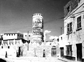
Before the colonial period Muqdisho was only one of a number of harbours serving the spice and slave market on the long sandy coast from the Arabian Peninsula to Zanzibar – the others included Hobya, Marka, Baraawe, Kismaayo, Lamu, Malindi, Mombassa and Pemba. In 1935 Muqdisho had about 40,000 inhabitants, by 1950, at the start of the Italian Trust Administration, it had about 70,000 and by the end of the trusteeship in 1960 the population had risen to 102,000.
The historic city of Muqdisho is made up of two parts: Xamar Weyne (Great city) and Shangaani. The buildings of these two districts, the so-called ancient ‘wall-houses’, are often multi‑family and almost always have several storeys. The roofs are supported by slender wooden rafters (buurti), typical to semi-desertic countries. The houses are built of coral stone and painted with lime-wash and are thickly clustered around streets which are almost always narrow (two to three metres). Openings to the street are usually limited to a main entrance, shop entrances and small french windows on the upper floors. Inside, there is generally a large central room from which the other rooms lead off. These are usually lower to permit the light to enter the main room from above. This arrangement also provides an opportunity to use transverse ventilation under the ceiling.
When Muqdisho was a colonial capital, the ancient city, expression of the historical encounter between Arab and African culture, was extended in the ‘European style’. Unfortunately, while the capitals of other colonial empires (Algiers, Luanda, Nairobi, etc) were assembling and reproducing in Africa some of the best examples of metropolitan architecture and town planning, Muqdisho developed like any mediocre Italian provincial town. The architecture of the expansion to the north of Xamar Weyne provides a good example of an uninspired attempt to impose order by a square grid of streets.
The first urban explosion, at the end of the 1930s, was towards the north, on the dunes which surround the urban centre. Beyond the administrative centre, the expansion took piace through a series of regulated subdivisions, starting from the villages of Shiibis and Bondheere (the word ‘village’ indicates in Muqdisho an indigenous district).
By the 1950s, the expansion through autonomous ‘villages’ continued: Anzillotti (now Waaberi) and Hodan to the west, and then in 1957 Wardhigley to the north. The result of this development was a city divided into three separate parts: the historical city almost intact in the centre, the self-sufficient European belt around it, and the autonomous ‘villages’ on the outskirts.
Planning initiatives
The first building activities outside the historic city were carried out by the Italians after 1910. In the 1920s the government offices (later to become the law courts) and the great cathedral (the largest in the Indian Ocean region) were constructed at the edge of Xamar Weyne. In 1929 the Governor, Guido Corni, order the preparation of the first town plan, aimed at directing the growing amount of building. This plan imposed a grid layout on the city, so the existing districts of Xamar Weyne and Shangaani would be gutted. In their place, near the harbour, there was to be a centre of commerce and services for the colonial city, while the indigenous population was to be pushed into an area of huts on the outskirts. It is interesting to re-read the comments made at the time on the objectives of the town plan: The concept which has inspired it is the creation of a new European city, totally separate from the indigenous one. The line of separation between the new European centre and the old indigenous district of Xamar Weyne was laid down in Corso Vittorio Emanuele. A study was immediately arranged of the clearance needed to permit the construction of wide streets and tree-lined squares in the indigenous district of Shangaani, which consists of foul huts and constructions which are so irrational and unhygienic as to be unfit for habitation by Europeans. After the huts of the areas to be reconstructed had been emptied, they were transported and re‑erected in a well-ordered and healthy village built on the dunes to the north of the city (1929).
In a later stage the expropriation and demolition of the rums of the indigenous houses was started, in order to make space for the new streets connecting the new city with Viale Vittorio Emanuele (1931 ).
A second town plan was drawn up in 1937 and approved in 1938. Later, an engineer named Tuccimei prepared a revised version, but this was never officially approved. There were, in any case, adaptations to the road network of the first plan in addition to the minor modifications which had been made in the course of carrying out the work. The plan to gut the old districts which predated the Italian occupation remained in these later plans, but the high costs of this project and the absence of private ground‑tax pressure forced this proposal to be postponed. So far it has been implemented only partially, with the opening of the wide street which lacerates the Shangaani district.
In 1960, at the time of independence, Muqdisho possessed a number of attributes favourable to its development as a capital city. At its centre, Xamar Weyne and Shangaani could provide a fertile cultural reference. Outside the city, there was the village concept. The land within the city was municipally owned and therefore immediately and fully available. However, it was wrongly supposed that the European city could be juxtaposed onto Somali culture and social conditions. This false assumption, combined with the population explosion which followed independence and has continued to accelerate , have meant that the city has never realised its true potential.
From 1962, the United Nations has financed a pilot project for the construction of cheap housing (guriyaha giimaha jaban), at a total cost of US$120,000, co-financed by the Somali government. In 1965 the National Housing Agency (NHA) was created, and a compound of 55 apartment buildings of cheap dwellings (Case Popolari) was constructed west of Muqdisho, between 1965 and 1972. One project of ‘urbanized plots’ was also realized when the NHA parcelled out and equipped 215 plots, selling them for a ‘political price’ of about US$1 per square metre.
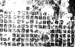
By 1968 the population had doubled to 204,000 and it reached 255,000 by 1970. From then on, natural disasters, wars and lack of planning have driven ever larger groups of families with no resources whatsoever into ‘parasitic’ immigration. The annual rate of population growth in the outskirts of Mogadishu is over 10%, with accompanying problems of congestion, lack of services and lack of hygiene. One of the first problems facing the revolutionary government installed at the end of 1969 was ensuring the orderly planned development of the capital. In 1970, the area occupied by permanent and temporary buildings, legal and illegal, was about 1,500 hectares. We can estimate that this is now in the region of 7,000 to 8,000. However, it is impossible to carry out a census of the nomadic families which are continually arriving and settling at the extreme edge in their traditional huts, known as aqal. According to the 1970 census, there were about 10,000 permanent masonry dwellings in Muqdisho, inhabited by 74,000 persons, and almost 20,000 temporary dwellings (including the shanties, but not the nomadic aqal), inhabited by 149,000 persons.
This imbalance has increased since the census and there are now probably less than 200,000 people in Muqdisho living in permanent dwellings. This implies that the congestion of the urban area and the irreversible decay of the outskirts are dangerously accelerating. There is an urgent need for a public construction programme to produce low‑cost housing in great quantity.
As indicated above, the development of the town after independence went forward with massive ‘temporary’ residential parcelling out of land. The local government assigned the plots and the occupants constructed their own houses or shanties, depending on the economic position of the family. Thus, Muqdishos housing stock gradually deteriorated, and a growing shantytown area now surrounds the capital along the entire length of the belt of dunes. The shantytown area also continues within the urban area, filling the once open spaces between one ‘village’ and the next.
In 1970 a Five Year Plan for the development of the urban area was drawn up. This envisaged new residential settlements on the high ground to the north, between the roads to Afgooye and Balcad. The total area covered by the plan was about 1,600 hectares, which would more than double the urban area and house at least 250,000 new inhabitants. Beyond these residential settlements, a new strip of mainly industrial and tertiary establishments (including new ministries and the university campus) was to complete urban expansion towards the hinterland. A 10 kilometre highway was built, which encloses the urban space toward the hinterland. Eight main roads set out from this highway and cross the town straight down to the sea, cutting through the sand dunes and valleys. This planning solution permits military control of the town, but it does not define the urban form of the individual sectors.
From 1972 to 1974, 300 apartments were built in the Case Popolari neighbourhood. In the new district, called ‘African Village’, the prices of the apartments exceeded US$2 500. As in other countries, the attempt to improve the city favoured the middle class, which could afford the initial investment.
In 1971 a research report by SAIS, an Italian research organisation made clear the need for territorial planning to precede any expansion of the town.
More recent planning initiatives have included a new deep‑water harbour which was constructed in the 1970s (thus increasing the town’s commercial activities); an offer from the Italian and FR German cooperation organisations to the Somali government of a research programme for a modern town plan of Muqdisho and the surrounding areas (about which no final decision has been made); and a survey of urban areas carried out on the basis of US satellite photographs.
Role and functions of Muqdisho
Like most African capitals, Muqdisho does not offer enough employment for the number of its inhabitants. One main reason for the growth of the town lies in its bureaucratic and administrative functions. A valuable source of income is provided by the expatriate technical and development cooperative personnel, who support a luxury economy very distinct from local consumption and create employment by recruiting service personnel: ‘boys’, night guardians, etc.
There is no real industrial zone in the city, although next to the harbour there is a freezer warehouse to stock the meat and fish. Industries based on agricultural products are situated in the periphery, at Balcad, Afgooye, and Jowhar, some 3060 kilometres from the city. However, a small industrial zone is anticipated, next to the oil refinery under construction at Jasira, 20 kilometres south of the city.
The area surrounding Muqdisho comprises an area of dunes between the Indian Ocean and the River Webi Shabelle, which runs parallel to the sea some 30 kilometres away. The fertile black soil in the valley irrigated by the river has meant that banana, papaya, mango and grapefruit plantations are located around the river.
Current problems (in 1980s)
The underlying objective in the planning projects of the 1970s was a halt to all immigration into the town and the creation of a kind of ‘green belt’ of agricultural villages (of about 20,000‑30,000 inhabitants each). These villages could settle people in the fertile valley of Webi Shabelle river.
The first parts of this ‘green belt’ were created in 1974, during the campaign to settle the nomads. However, the villages which were created in this project had a very short life as, rather than adapt to such a radical change in their way of life, all the adults escaped to return to a nomadic life or move to the capital.
The defeat of this campaign took place at the same time as the war of 1978, a period of political instability and industrial stagnation. Muqdisho’s role as a Iservice town’ has since increased and it was not until 1981 that new aid agreements with the West made it possible to consider again the development of its industrial production.
The position of Muqdisho in relation to the rest of the country creates a problem of territorial balance : how can the growth of Muqdisho as the only development pole (the only port and commercial centre) of the country be avoided? Today this territorial imbalance is emphasised by the drought, which has depopulated the peripheral areas along the coast north of Muqdisho. However, in the south the two ports of Kismmayo and Baraawe could constitute alternative development poles. Furthermore, the area between Muqdisho and Kismaayo is the only fertile zone of Somalia, owing to the rivers Jubba and Webi Shabelle. However, the contrast between the southern and northern parts of the country has increased. This is mainly due to the desert zone (over 1,000 square kilometres) which separates the fertile zone from the uninhabited mountains in the north (former British Somaliland).
The urban environment, which had never been good, deteriorated rapidly after independence, mainly as the result of nomads migrating to the town. These population movements have led to a chronic deficiency in the already inadequate social infrastructures, with increasingly serious consequences. A 1965 report" described Muqdisho thus:
“Over 70% of the population lives in subhuman conditions, in awful districts lacking the most elementary services. Settlement in the town and in its surroundings continues to increase, without any concern for the availability of suitable dwellings or the related services and infrastructure. The new arrivals overcrowd already congested districts or erect shelters of any available material on any land which may be available, creating chaotic high density groupings, with not even elementary services, transforming a healthy environment into a hive of disease, discontent and crime”.
The only change which has taken place since 1965 has been a multiplication of the problems by three or four times. After the failure of an attempt to expand towards the east (Karan village), the rapidly growing population has tended to saturate the existing urban area, by invading the areas reserved for utilities or open space and welding the formerly separate ‘villages’ into a single, almost continuous belt of temporary or illegal constructions. The original idea of ‘villages’ as separate and potentially autonomous residential units has also been almost completely nullified.
The land policy established in 1970 seems to have been largely overwhelmed by the spread of illegal building, including temporary building, which followed the famine of 1974‑75. Instead of new regulations, it would therefore be better to have direct public support of self-construction by providing design suggestions and semi‑ manufactured materials (for example simple wall panels constructed of local materials). This would also offer the minimum standards of hygiene and comfort.
Possible solutions
As a country destitute of natural resources, Somalia is highly dependent on international agencies for the financing of development projects. The only alternative to large‑scale international aid would be a policy of self-reliance, and the extensive participation of the people in the improvement and management of their habitat and urban structures. However, it seems that the current political regime is not able to make participatory mechanisms work, nor to provide the population with the basic knowledge necessary. In this sense analogous experiences in Africa (e.g. in Tanzania and Zambia) could be useful.
An international campaign of volunteers, combined with the participation of local students, could make a start towards identifying and solving Muqdisho’s alarming problems. However, although this kind of mobilisation might have been possible in the 1970s at the beginning of the ‘revolutionary’ period of the current Somali regime, at the moment it is doubtful whether governmental organisations of the developed countries have good enough relations with the Somali government to allow them to conduct the necessary research into the causes of urban sprawl and poverty in the capital. This aspect of the Somali modesty is proverbial: it has always been forbidden to take photos in the poorest districts. Instead of admitting the existence of the shantytowns, the authorities have instead tried to forget them and their inhabitants.
Cities, Guildford – UK, nr. 3, Feb. 1984